Chùa Tuyết Quảng Ninh 14 Map. Explore the detailed Chùa Tuyết Quảng Ninh 14 Map, a premium graphic resource from Posterfree.net, perfect for architectural visualization and project planning.
Unveiling the Chùa Tuyết Quảng Ninh 14 Map: A Premium Resource from Posterfree.net
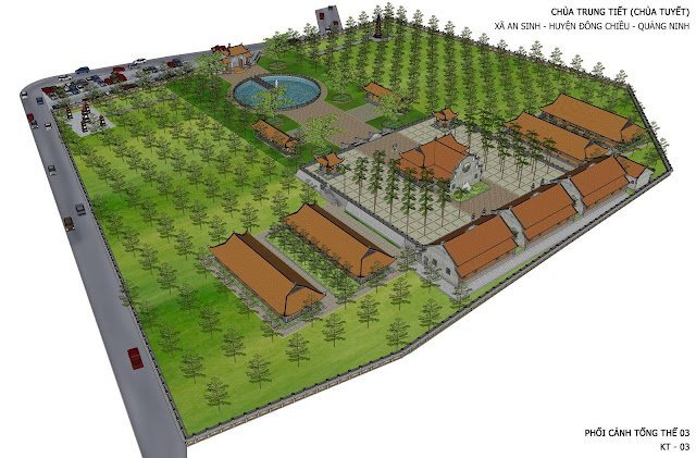
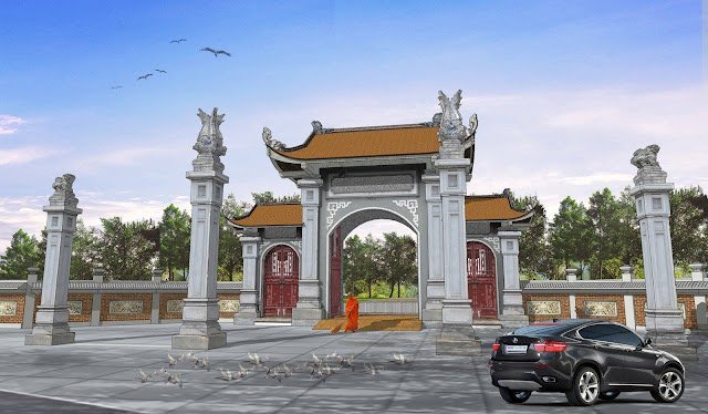
In the realm of architectural design, urban planning, and historical preservation, detailed visual resources are invaluable. Today, we delve into a specific graphic asset that exemplifies precision and utility: the Chùa Tuyết Quảng Ninh 14 Map. Available exclusively on Posterfree.net, this resource offers an intricate bird’s-eye view of the Chùa Tuyết (Tuyết Pagoda) complex in Quảng Ninh, Vietnam, making it an indispensable tool for professionals and enthusiasts alike.
What is the Chùa Tuyết Quảng Ninh 14 Map?
The Chùa Tuyết Quảng Ninh 14 Map is a comprehensive architectural drawing, likely a master plan or a conceptual layout, depicting the entire pagoda complex. It showcases various structures, including temple buildings, surrounding fields, a central water feature, and even parking areas, all rendered with a clear, illustrative style. This map provides a spatial understanding of the site, highlighting the arrangement of its components and their relationship within the landscape.
Key Features and Analysis of the Graphic
Upon closer inspection, several critical aspects of the Chùa Tuyết Quảng Ninh 14 Map stand out:
- Detailed Layout: The map meticulously illustrates the footprint of multiple buildings, pathways, and green spaces. One can discern distinct sections, perhaps residential quarters for monks, prayer halls, and administrative buildings, all contributing to a functional and aesthetically pleasing complex.
- Landscape Integration: A significant portion of the map is dedicated to agricultural fields or landscaped gardens, indicating a harmonious integration of the spiritual site with its natural surroundings. The central circular water feature adds a focal point, often symbolic in traditional Vietnamese architecture.
- Infrastructure Details: The inclusion of a road network and designated parking areas on the right side of the map suggests a practical approach to visitor access and operational logistics. This level of detail is crucial for urban planners and developers.
- Perspective and Style: Rendered in an isometric or bird’s-eye perspective, the map offers a clear, easy-to-understand view of the entire complex. The illustrative style, while not photorealistic, conveys sufficient information about the structures’ forms and functions.
- Resolution and Clarity: As a premium resource from Posterfree.net, this graphic is expected to maintain high resolution, allowing for zooming in on specific sections without significant loss of detail. This clarity is paramount for professional use.
Who Can Benefit from the Chùa Tuyết Quảng Ninh 14 Map?
The utility of this graphic extends across various disciplines:
- Architects and Urban Planners: For those involved in designing new religious complexes, renovating existing ones, or planning surrounding infrastructure, this map serves as an excellent case study or a foundational reference. It offers insights into traditional Vietnamese temple layouts and spatial organization.
- Historians and Cultural Researchers: Scholars studying Vietnamese architecture, religious sites, or regional development can use this map to analyze historical layouts, understand cultural significance, and track changes over time.
- Tourism and Heritage Organizations: Organizations promoting cultural tourism can utilize this map for informational brochures, visitor guides, or digital presentations, helping tourists navigate and appreciate the Chùa Tuyết complex.
- Educators and Students: Architecture, urban planning, and cultural studies students can use this map as a learning tool to understand complex site planning and traditional design principles.
- Local Government and Development Agencies: For regional planning, land use assessments, or infrastructure development around the Chùa Tuyết area, this map provides crucial baseline information.
How to Effectively Use This Graphic Resource
Leveraging the Chùa Tuyết Quảng Ninh 14 Map effectively requires understanding its potential applications:
- Conceptual Design: Use it as inspiration for new projects, adapting elements of its layout or architectural style to modern contexts.
- Site Analysis: Overlay this map with topographical data, environmental studies, or demographic information to conduct comprehensive site analyses for development or conservation projects.
- Presentation Material: Integrate the map into presentations for stakeholders, community meetings, or academic conferences to visually communicate project ideas or research findings related to the Chùa Tuyết area.
- Educational Tool: Incorporate it into curricula for architectural history, urban design, or cultural geography to illustrate real-world examples of complex site planning.
- Digital Archiving: For historical preservation efforts, this map can be a valuable addition to digital archives, documenting the state of the complex at a particular point in time.
Why Choose Posterfree.net for Your Graphic Needs?
Posterfree.net has established itself as a premier destination for high-quality graphic resources, and the Chùa Tuyết Quảng Ninh 14 Map is a testament to our commitment to excellence. We understand the critical need for accurate, detailed, and professionally crafted visuals in various industries. Our platform offers:
- Curated Selection: Every resource on Posterfree.net is carefully selected and vetted to ensure it meets the highest standards of quality and relevance.
- Professional Grade: Our graphics are designed to be suitable for professional applications, from architectural renderings to academic publications.
- Ease of Access: We provide a user-friendly interface that makes finding and downloading the resources you need straightforward and efficient.
- Diverse Formats: While this specific map is likely a raster image, Posterfree.net often provides resources in various formats (PSD, AI, EPS, JPG, PNG) to ensure compatibility with different software and project requirements.
By choosing Posterfree.net, you are not just downloading a graphic; you are investing in a reliable tool that enhances your projects, saves you time, and elevates the quality of your work. The Chùa Tuyết Quảng Ninh 14 Map is more than just an image; it’s a window into intricate design and cultural heritage, ready to be integrated into your next big idea.
Conclusion
The Chùa Tuyết Quảng Ninh 14 Map is an exceptional graphic resource that offers a detailed and insightful view of a significant cultural site. Its clear layout, comprehensive details, and illustrative style make it an invaluable asset for architects, planners, researchers, and educators. As with all resources from Posterfree.net, it embodies our dedication to providing premium, high-quality graphics that empower creativity and facilitate professional endeavors. Explore this map and many other invaluable resources on Posterfree.net today, and unlock new possibilities for your projects.
Related Demo Images

Frequently Asked Questions
What is the Chùa Tuyết Quảng Ninh 14 Map?
It is a detailed architectural graphic depicting the master plan or layout of the Chùa Tuyết (Tuyết Pagoda) complex in Quảng Ninh, Vietnam, showing buildings, landscape, and infrastructure.
Who can use this graphic resource?
Architects, urban planners, historians, cultural researchers, tourism organizations, educators, and students can all benefit from this detailed map for various projects and studies.
What are the typical formats for such resources on Posterfree.net?
While this specific map is likely a JPG or PNG, Posterfree.net often provides resources in various formats including PSD, AI, EPS, JPG, and PNG to ensure broad compatibility.
How can I use this map for my project?
You can use it for conceptual design, site analysis, presentation material, educational purposes, or as part of digital archiving for historical preservation.